


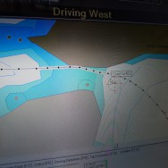


We learned a valuable lesson on the way from Symi to Kos, which is to never trust the GPS maps because they simply aren’t accurate. In our case we found this out as we left Symi and headed through a very narrow and shallow pass between Symi and a tiny island just to the north. We went right down the center of the pass as the pilot book says. But if we had attempted this in the dark and were relying on our GPS charts, instead of visual observations, we would have driven straight up onto the shore. The maps have the pass mis-marked by about 30 meters, so as we went through the pass our GPS was telling us we were ashore. We’ve heard this countless times that none of the navigational charts are accurate, but this experience made it all crystal clear.
After making it through the pass we sailed straight into Turkish waters and hugged the Turkish coast all the way to Kos. We didn’t check-in to Turkey or even tell them we were transiting through their waters. If we were a military ship this might be considered an act of war, but for a harmless pleasure ship like ours, nobody cares or even thinks twice about it – it’s standard procedure and everybody does it.
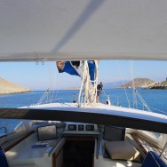
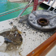
By the time we arrived in Kos, we had lost our 110 volt AC electrical system, and our primary winch had failed (the one which hoists and trims our main sail). We’re now in the familiar position of waiting around the harbor for things to get fixed. We’re not complaining about that because we can’t imagine a better place to be stuck for a few days.